
Haywood County topographic map
Interactive map
Click on the map to display elevation.
About this map
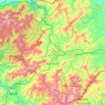
Name: Haywood County topographic map, elevation, terrain.
Location: Haywood County, North Carolina, United States of America (35.29163 -83.25743 35.79096 -82.74514)
Average elevation: 1,044 m
Minimum elevation: 477 m
Maximum elevation: 1,998 m
Haywood County is situated amidst the Blue Ridge Mountains and contains parts of several major subranges of the Blue Ridge, namely the Great Smoky Mountains in the west and the Plott Balsams and Great Balsam Mountains in the south. Notable peaks in the county include Cold Mountain, at 6,030 feet (1,840 m), Mount Sterling, at 5,835 feet (1,779 m), and Richland Balsam, at 6,410 feet (1,950 m) in elevation. Mt. Guyot, the county's highest point at 6,621 feet (2,018 m), is the 4th highest mountain east of the Mississippi River. Black Balsam Knob, in the Great Balsam Mountains in the southeastern section of the county, is the highest grassy bald in the entire Appalachian range. Haywood County is believed to be the highest county (by mean elevation) east of the Mississippi River, with a mean elevation of 3,600 feet or 1,097 metres.
Other topographic maps
Click on a map to view its topography, its elevation and its terrain.
Transylvania County
United States of America > North Carolina
Transylvania County, North Carolina, United States of America
Average elevation: 898 m
Eden
United States of America > North Carolina > Eden
Eden, Rockingham County, North Carolina, 27288, United States of America
Average elevation: 191 m
Ashe County
United States of America > North Carolina
Ashe County, North Carolina, United States of America
Average elevation: 950 m
Brightwater
United States of America > North Carolina > Brightwater
Brightwater, Henderson County, North Carolina, 28791, United States of America
Average elevation: 728 m
Davidson County
United States of America > North Carolina
Davidson County, North Carolina, United States of America
Average elevation: 222 m
Surry County
United States of America > North Carolina
Surry County, North Carolina, United States of America
Average elevation: 393 m
Edgecombe County
United States of America > North Carolina
Edgecombe County, North Carolina, United States of America
Average elevation: 28 m
Farrington
United States of America > North Carolina > Farrington
Farrington, Chatham County, North Carolina, United States of America
Average elevation: 75 m
Vox
United States of America > North Carolina > Vox
Vox, Alleghany County, North Carolina, United States of America
Average elevation: 828 m
Buncombe County
United States of America > North Carolina
Buncombe County, North Carolina, United States of America
Average elevation: 839 m
Graham County
United States of America > North Carolina
Graham County, North Carolina, United States of America
Average elevation: 850 m
Carteret County
United States of America > North Carolina
Carteret County, North Carolina, United States of America
Average elevation: 2 m
Guilford County
United States of America > North Carolina
Guilford County, North Carolina, United States of America
Average elevation: 239 m
Appalachian Mountains
United States of America > North Carolina
Appalachian Mountains, Yancey County, North Carolina, United States of America
Average elevation: 1,463 m