
Moldoveanu topographic map
Interactive map
Click on the map to display elevation.
About this map
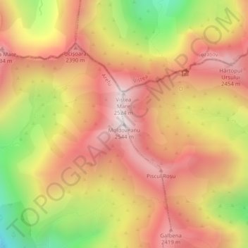
Name: Moldoveanu topographic map, elevation, terrain.
Location: Moldoveanu, Argeș, Romania (45.59951 24.73611 45.59961 24.73621)
Average elevation: 2,142 m
Minimum elevation: 1,570 m
Maximum elevation: 2,520 m
Other topographic maps
Click on a map to view its topography, its elevation and its terrain.
Neagra Șarului
Neagra Șarului, Șaru Dornei, Suceava, 727517, Romania
Average elevation: 981 m
Calina
Romania > Caraș-Severin > Calina
Calina, Dognecea, Caraș-Severin, 327181, Romania
Average elevation: 285 m
Danube Delta Biosphere Reserve
Danube Delta Biosphere Reserve, Tulcea, 827051, Romania
Average elevation: 3 m
Retezat National Park
Retezat National Park, Hunedoara, Romania
Average elevation: 1,443 m