
Waitematā Harbour topographic map
Interactive map
Click on the map to display elevation.
About this map
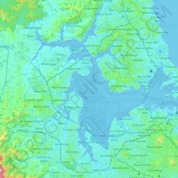
Name: Waitematā Harbour topographic map, elevation, terrain.
Location: Waitematā Harbour, Henderson-Massey, Auckland, New Zealand (-36.90576 174.59144 -36.73672 174.83128)
Average elevation: 40 m
Minimum elevation: -1 m
Maximum elevation: 350 m
Auckland trails, hiking, mountain biking, running and outdoor activities
Other topographic maps
Click on a map to view its topography, its elevation and its terrain.