
Black Island topographic map
Interactive map
Click on the map to display elevation.
About this map
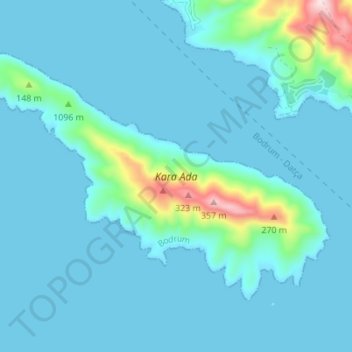
Name: Black Island topographic map, elevation, terrain.
Location: Black Island, Muğla, Aegean Region, Turkey (36.95791 27.42388 36.99683 27.49287)
Average elevation: 40 m
Minimum elevation: 0 m
Maximum elevation: 376 m
Other topographic maps
Click on a map to view its topography, its elevation and its terrain.
Ekinambarı
Turkey > Aegean Region > Ekinambarı
Ekinambarı, Milas, Muğla, Aegean Region, Turkey
Average elevation: 9 m