
Lumsden No. 189 topographic map
Interactive map
Click on the map to display elevation.
About this map
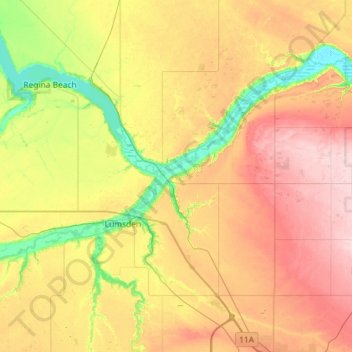
Name: Lumsden No. 189 topographic map, elevation, terrain.
Location: Lumsden No. 189, Saskatchewan, Canada (50.57159 -105.05549 50.81927 -104.47812)
Average elevation: 568 m
Minimum elevation: 482 m
Maximum elevation: 668 m
Other topographic maps
Click on a map to view its topography, its elevation and its terrain.
Saskatoon
Canada > Saskatchewan > Saskatoon
Saskatoon lies on a long belt of rich, potassic chernozem in middle-southern Saskatchewan and is found in the aspen parkland biome. The lack of surrounding mountainous topography gives the city a relatively flat grid, though the city does sprawl over a few hills and into a few valleys. The lowest point in the…
Average elevation: 510 m