
Make a donation
Doubtful Sound topographic map
Click on the map to display elevation.
Make a donation
About this map
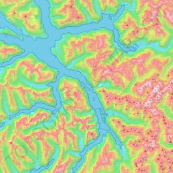
Name: Doubtful Sound topographic map, elevation, terrain.
Average elevation: 560 m
Minimum elevation: -1 m
Maximum elevation: 1,636 m
Southland District trails, hiking, mountain biking, running and outdoor activities
Make a donation
Other topographic maps
Click on a map to view its topography, its elevation and its terrain.
Pembroke Glacier
New Zealand > Southland > Southland District > Fiordland Community
Average elevation: 1,211 m
Twin Sisters
New Zealand > Southland > Southland District > Fiordland Community
Average elevation: 1,039 m
Make a donation
Hineteawa / Bowen Falls
New Zealand > Southland > Southland District > Fiordland Community
Average elevation: 232 m
Waimānu / Stirling Falls
New Zealand > Southland > Southland District > Fiordland Community
Average elevation: 423 m
Eldrig Peak
New Zealand > Southland > Southland District > Fiordland Community
Average elevation: 1,155 m
Mount Elliot
New Zealand > Southland > Southland District > Fiordland Community
Average elevation: 1,110 m
Make a donation
Pearl Harbour
New Zealand > Southland > Southland District > Fiordland Community > Manapouri
Average elevation: 212 m
Make a donation
Mount Owen
New Zealand > Southland > Southland District > Fiordland Community
Average elevation: 1,269 m
Sutherland Falls
New Zealand > Southland > Southland District > Fiordland Community
Average elevation: 1,006 m
Make a donation
Turner Falls
New Zealand > Southland > Southland District > Fiordland Community
Average elevation: 1,335 m
Milford Sound
New Zealand > Southland > Southland District > Fiordland Community > Milford Sound
Average elevation: 304 m
Depth Peak
New Zealand > Southland > Southland District > Fiordland Community
Average elevation: 680 m
Mitre Peak
New Zealand > Southland > Southland District > Fiordland Community
Average elevation: 657 m
Make a donation
Mount Makere
New Zealand > Southland > Southland District > Fiordland Community
Average elevation: 1,433 m