
County Wexford topographic map
Interactive map
Click on the map to display elevation.
About this map
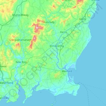
Name: County Wexford topographic map, elevation, terrain.
Location: County Wexford, Leinster, Ireland (52.10863 -7.01781 52.79746 -6.14069)
Average elevation: 63 m
Minimum elevation: -4 m
Maximum elevation: 784 m
Other topographic maps
Click on a map to view its topography, its elevation and its terrain.
Blackstone
Blackstone, Killag ED, The Borough District of Wexford, County Wexford, Leinster, Ireland
Average elevation: 5 m
Rathmore
Rathmore, Kilscoran ED, The Borough District of Wexford, County Wexford, Leinster, Ireland
Average elevation: 21 m
Ferns
Ireland > County Wexford > Ferns
Ferns, The Municipal District of Enniscorthy, County Wexford, Leinster, Y21 E8D5, Ireland
Average elevation: 60 m