
Thank you for supporting this site ❤️
Make a donation
Make a donation
Tello topographic map
Click on the map to display elevation.
Thank you for supporting this site ❤️
Make a donation
Make a donation
About this map
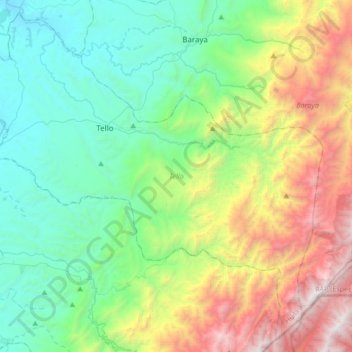
Name: Tello topographic map, elevation, terrain.
Location: Tello, Norte, Huila, Región Andina, Colombia (2.86385 -75.26806 3.17810 -74.93034)
Average elevation: 1,216 m
Minimum elevation: 382 m
Maximum elevation: 3,194 m
Thank you for supporting this site ❤️
Make a donation
Make a donation
Other topographic maps
Click on a map to view its topography, its elevation and its terrain.