
Tagbilaran topographic map
Interactive map
Click on the map to display elevation.
About this map
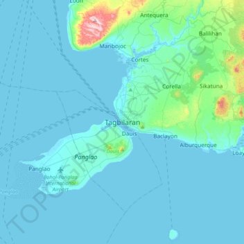
Name: Tagbilaran topographic map, elevation, terrain.
Location: Tagbilaran, Bohol, Central Visayas, 6390, Philippines (9.48026 123.69598 9.80026 124.01598)
Average elevation: 35 m
Minimum elevation: -2 m
Maximum elevation: 437 m
Other topographic maps
Click on a map to view its topography, its elevation and its terrain.
Tagbilaran City Friendship Park
Philippines > Bohol > Tagbilaran
Tagbilaran City Friendship Park, Bool, Tagbilaran, Bohol, Central Visayas, 6301, Philippines
Average elevation: 23 m