Geolocate

Porac topographic map

Interactive map

Click on the map to display elevation.

About this map

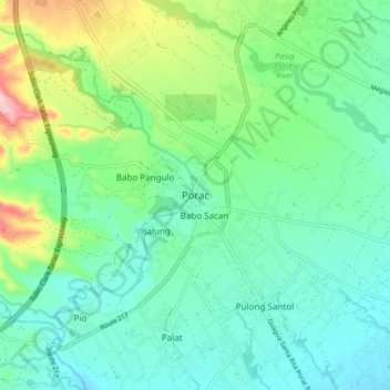
Name: Porac topographic map, elevation, terrain.

Location: Porac, Pampanga, Central Luzon, 2008, Philippines (15.03265 120.50302 15.11265 120.58302)

Average elevation: 91 m

Minimum elevation: 34 m

Maximum elevation: 256 m

Other topographic maps

Click on a map to view its topography, its elevation and its terrain.

Apalit

Philippines > Pampanga

Average elevation: 4 m

Masantol

Philippines > Pampanga

Average elevation: 3 m

Arayat

Philippines > Pampanga

Average elevation: 39 m

Santa Rita

Philippines > Pampanga

Average elevation: 20 m

Sapang Maragul

Philippines > Pampanga > Guagua > San Matias

Average elevation: 5 m

Pasig-Potrero River

Philippines > Pampanga

Average elevation: 77 m

Barangay Dolores Plaza

Philippines > Pampanga > Porac

Average elevation: 133 m

San Fernando

Philippines > Pampanga

Average elevation: 15 m

Lubao

Philippines > Pampanga

Average elevation: 6 m

Magalang

Philippines > Pampanga

Average elevation: 57 m

Guagua

Philippines > Pampanga

The climate and topographical features of the vast land of Guagua make it ideal for the growing of fruit trees and vegetables. Among the fruit trees most fitting to be planted are mangoes, guavas, santol, star apples, and bananas. For vegetables, sitao, upo, ampalaya, gabi and cucumber are the most commonly…

Average elevation: 9 m

Sacobia River

Philippines > Pampanga > Mabalacat

Average elevation: 167 m

Pampanga River

Philippines > Pampanga

Average elevation: 127 m

San Simon

Philippines > Pampanga

Average elevation: 5 m