
Södermalm topographic map
Interactive map
Click on the map to display elevation.
Södermalm
The name Södermalm (as Suthaermalm) is first mentioned in 1288 in a letter from Bishop Anund of Strängnäs. Until the early 17th century Södermalm was mainly a rural, agricultural area. Its first urban areas were planned and built in the mid 17th century, comprising a mixture of working class housing, such as the little red cottages of which a few can still be seen in northeastern Södermalm, and the summer houses and pavilions of wealthier families, such as Emanuel Swedenborg's pavilion, which is now in the outdoor museum Skansen. During this time, it was also the location of perhaps the first theatre in Scandinavia, Björngårdsteatern. Södermalm is often poetically named Söders höjder ("heights of the south"), which reflects its topography of sheer cliffs and rocky hills. Indeed, the hills of Södermalm provide remarkable views of Stockholm's skyline.
About this map
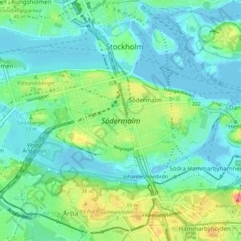
Name: Södermalm topographic map, elevation, terrain.
Average elevation: 22 m
Minimum elevation: -2 m
Maximum elevation: 87 m