
Becker County topographic map
Interactive map
Click on the map to display elevation.
About this map
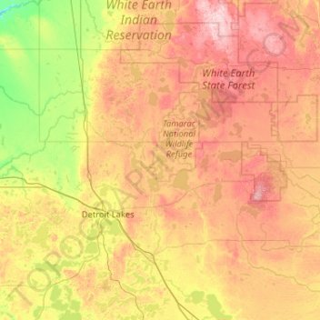
Name: Becker County topographic map, elevation, terrain.
Location: Becker County, Minnesota, United States (46.71753 -96.19484 47.15256 -95.16219)
Average elevation: 439 m
Minimum elevation: 324 m
Maximum elevation: 597 m
Becker County has diverse topography. It is home to several hundred lakes, many acres of fertile farm land, and forested areas. Much of the land consists of hills and deciduous trees.
Other topographic maps
Click on a map to view its topography, its elevation and its terrain.
Lonsdale
United States > Minnesota > Rice County
Lonsdale, Rice County, Minnesota, 55046, United States
Average elevation: 336 m
Wade Brook
United States > Minnesota > Koochiching County
Wade Brook, Koochiching County, Minnesota, United States
Average elevation: 406 m
Cass Lake
United States > Minnesota > Cass County
Cass Lake, Cass County, Minnesota, United States
Average elevation: 402 m
Wescott
United States > Minnesota > Dakota County > Inver Grove Heights
Wescott, Inver Grove Heights, Dakota County, Minnesota, 55077, United States
Average elevation: 269 m
Duluth
United States > Minnesota > Saint Louis County
Duluth, Saint Louis County, Minnesota, United States
Average elevation: 286 m
Buffalo
United States > Minnesota > Wright County
Buffalo, Wright County, Minnesota, 55313, United States
Average elevation: 297 m
Crow Wing County
Crow Wing County, Minnesota, United States
Average elevation: 386 m
Winton
United States > Minnesota > Saint Louis County
Winton, Saint Louis County, Minnesota, 55796, United States
Average elevation: 414 m
Linden Grove
United States > Minnesota > Saint Louis County
Linden Grove, Saint Louis County, Minnesota, United States
Average elevation: 397 m
Atwater
United States > Minnesota > Kandiyohi County
Atwater, Kandiyohi County, Minnesota, United States
Average elevation: 372 m
La Prairie
United States > Minnesota > Itasca County
La Prairie, Itasca County, Minnesota, United States
Average elevation: 393 m
Brunner Lake
United States > Minnesota > Goodhue County > Red Wing
Brunner Lake, Red Wing, Goodhue County, Minnesota, United States
Average elevation: 228 m
Stephen
United States > Minnesota > Stephen
Stephen, Marshall County, Minnesota, 56757, United States
Average elevation: 253 m
Horseshoe Island
Horseshoe Island, Lake County, Minnesota, United States
Average elevation: 419 m
Benton County
Benton County, Minnesota, United States
Average elevation: 340 m
Shakopee
United States > Minnesota > Shakopee
Shakopee, Scott County, Minnesota, 55379, United States
Average elevation: 257 m
Riverside
United States > Minnesota > Duluth > Riverside
Riverside, Duluth, Saint Louis County, Minnesota, 55808, United States
Average elevation: 242 m
Champlin
United States > Minnesota > Champlin
Champlin, Hennepin County, Minnesota, 55316, United States
Average elevation: 265 m
Stillwater
United States > Minnesota > Stillwater
Stillwater, Washington County, Minnesota, 55082, United States
Average elevation: 259 m
Maple Grove
United States > Minnesota > Maple Grove
Maple Grove, Hennepin County, Minnesota, United States
Average elevation: 278 m
Brainerd
United States > Minnesota > Brainerd
Brainerd, Crow Wing County, Minnesota, 56401, United States
Average elevation: 370 m
Makinen
United States > Minnesota > Makinen
Makinen, Saint Louis County, Minnesota, United States
Average elevation: 420 m
Minnetonka
United States > Minnesota > Minnetonka
Minnetonka, Hennepin County, Minnesota, United States
Average elevation: 290 m
Lake Elmo
United States > Minnesota > Lake Elmo
Lake Elmo, Washington County, Minnesota, 55042, United States
Average elevation: 287 m
Saint Louis County
Saint Louis County, Minnesota, United States
Average elevation: 398 m
Ramsey County
Ramsey County, Minnesota, United States
Average elevation: 279 m