
Tonbridge and Malling topographic map
Interactive map
Click on the map to display elevation.
About this map
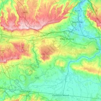
Name: Tonbridge and Malling topographic map, elevation, terrain.
Location: Tonbridge and Malling, Kent, South East, England, United Kingdom (51.17470 0.20052 51.36876 0.52675)
Average elevation: 77 m
Minimum elevation: -3 m
Maximum elevation: 236 m
Other topographic maps
Click on a map to view its topography, its elevation and its terrain.
Tonbridge
United Kingdom > England > Tonbridge and Malling > Tonbridge
Tonbridge, Tonbridge and Malling, Kent, South East, England, TN9 2AN, United Kingdom
Average elevation: 55 m