
Chattanooga topographic map
Interactive map
Click on the map to display elevation.
About this map
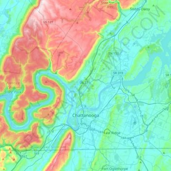
Name: Chattanooga topographic map, elevation, terrain.
Location: Chattanooga, Hamilton County, Tennessee, United States (34.98298 -85.42556 35.21435 -85.05159)
Average elevation: 331 m
Minimum elevation: 189 m
Maximum elevation: 722 m
With a downtown elevation of about 680 feet (210 m), Chattanooga is at the transition between the ridge-and-valley portion of the Appalachian Mountains and the Cumberland Plateau. Its official nickname is "Scenic City", alluding to the surrounding by mountains and ridges. Unofficial nicknames include "River City", "Chatt", "Nooga", "Chattown", and "Gig City", the latter a reference to Chattanooga's claims that it has the fastest internet service in the Western Hemisphere.