
Olsztyn topographic map
Interactive map
Click on the map to display elevation.
About this map
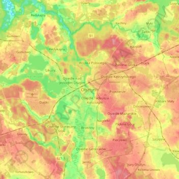
Name: Olsztyn topographic map, elevation, terrain.
Location: Olsztyn, Olsztyn County, Warmian-Masurian Voivodeship, Poland (53.72421 20.36649 53.82902 20.56665)
Average elevation: 123 m
Minimum elevation: 78 m
Maximum elevation: 157 m
Other topographic maps
Click on a map to view its topography, its elevation and its terrain.
Dost
Poland > Warmian-Masurian Voivodeship > Olsztyn County > Polkajmy
Dost, Polkajmy, gmina Jeziorany, Olsztyn County, Warmian-Masurian Voivodeship, 11-320, Poland
Average elevation: 119 m
Olsztyn
Poland > Warmian-Masurian Voivodeship > Olsztyn
Olsztyn, Warmian-Masurian Voivodeship, Poland
Average elevation: 123 m
Pisz
Poland > Warmian-Masurian Voivodeship > Pisz County > Pisz > Pisz
Pisz, gmina Pisz, Pisz County, Warmian-Masurian Voivodeship, 12-200, Poland
Average elevation: 118 m
Mrągowo County
Poland > Warmian-Masurian Voivodeship
Mrągowo County, Warmian-Masurian Voivodeship, Poland
Average elevation: 141 m
Elbląg
Poland > Warmian-Masurian Voivodeship
Elbląg, Elbląg County, Warmian-Masurian Voivodeship, 82-300, Poland
Average elevation: 75 m
Mrągowo
Poland > Warmian-Masurian Voivodeship > Mrągowo
Mrągowo, powiat mrągowski, Warmian-Masurian Voivodeship, 11-700, Poland
Average elevation: 150 m
Olsztynek
Poland > Warmian-Masurian Voivodeship > Olsztynek
Olsztynek, gmina Olsztynek, powiat olsztyński, Warmian-Masurian Voivodeship, 11-015, Poland
Average elevation: 174 m
Olecko
Poland > Warmian-Masurian Voivodeship > Olecko
Olecko, gmina Olecko, powiat olecki, Warmian-Masurian Voivodeship, 19-401, Poland
Average elevation: 170 m