
Stratford-on-Avon topographic map
Interactive map
Click on the map to display elevation.
About this map
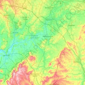
Name: Stratford-on-Avon topographic map, elevation, terrain.
Average elevation: 108 m
Minimum elevation: 20 m
Maximum elevation: 320 m
Other topographic maps
Click on a map to view its topography, its elevation and its terrain.
Crimscote
United Kingdom > England > Stratford-on-Avon > Alderminster > Crimscote
Crimscote, Whitchurch CP, Alderminster, Stratford-on-Avon, Warwickshire, West Midlands, England, CV37 8UE, United Kingdom
Average elevation: 70 m
Ilmington
United Kingdom > England > Stratford-on-Avon > Ilmington
Ilmington, Stratford-on-Avon, Warwickshire, West Midlands, England, CV36 4LB, United Kingdom
Average elevation: 122 m
Harbury
United Kingdom > England > Stratford-on-Avon > Harbury
Harbury, Stratford-on-Avon, Warwickshire, West Midlands, England, CV33 9HW, United Kingdom
Average elevation: 103 m