
Mount Malinao topographic map
Interactive map
Click on the map to display elevation.
About this map
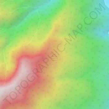
Name: Mount Malinao topographic map, elevation, terrain.
Location: Mount Malinao, Albay, Bicol Region, Philippines (13.41078 123.62717 13.41088 123.62727)
Average elevation: 964 m
Minimum elevation: 420 m
Maximum elevation: 1,512 m
Other topographic maps
Click on a map to view its topography, its elevation and its terrain.
Tabaco
The City of Tabaco is located on the eastern coast of Albay province with an area of 117.14 km2 (45.23 sq mi). The terrain in the poblacion or town center of Tabaco is generally flat with the highest elevation at around 5 m (16 ft). The northwestern portion reaches 400 m (1,300 ft) above sea level. The city's…
Average elevation: 164 m