
Thank you for supporting this site ❤️
Make a donation
Make a donation
Norzagaray topographic map
Click on the map to display elevation.
Thank you for supporting this site ❤️
Make a donation
Make a donation
About this map
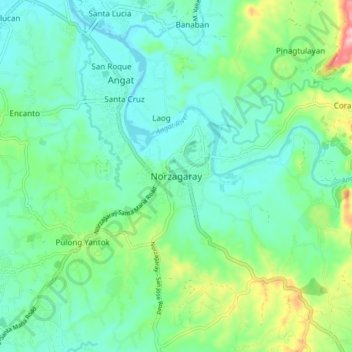
Name: Norzagaray topographic map, elevation, terrain.
Location: Norzagaray, Bulacan, Central Luzon, 3013, Philippines (14.86588 121.00218 14.94588 121.08218)
Average elevation: 66 m
Minimum elevation: 21 m
Maximum elevation: 203 m
Thank you for supporting this site ❤️
Make a donation
Make a donation
Other topographic maps
Click on a map to view its topography, its elevation and its terrain.
Thank you for supporting this site ❤️
Make a donation
Make a donation
Thank you for supporting this site ❤️
Make a donation
Make a donation
Thank you for supporting this site ❤️
Make a donation
Make a donation
Doña Remedios Trinidad
List of highest peaks in D.R.T by elevation.
Average elevation: 172 m