
Doncaster topographic map
Interactive map
Click on the map to display elevation.
About this map
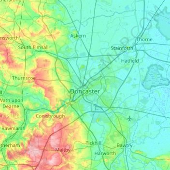
Name: Doncaster topographic map, elevation, terrain.
Location: Doncaster, Yorkshire and the Humber, England, United Kingdom (53.40574 -1.34873 53.66120 -0.86533)
Average elevation: 31 m
Minimum elevation: -1 m
Maximum elevation: 153 m
Other topographic maps
Click on a map to view its topography, its elevation and its terrain.
Nottinghamshire
United Kingdom > England > Doncaster
Nottinghamshire, Bankwood Lane, Rossington, Doncaster, Yorkshire and the Humber, England, DN11 0PS, United Kingdom
Average elevation: 74 m