
Make a donation
Kaikohe-Hokianga Community topographic map
Click on the map to display elevation.
Make a donation
About this map
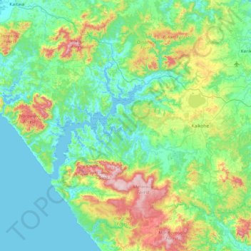
Name: Kaikohe-Hokianga Community topographic map, elevation, terrain.
Average elevation: 159 m
Minimum elevation: -1 m
Maximum elevation: 750 m
Far North District trails, hiking, mountain biking, running and outdoor activities
Make a donation
Other topographic maps
Click on a map to view its topography, its elevation and its terrain.
Tautoro
New Zealand > Northland > Far North District > Kaikohe-Hokianga Community
Average elevation: 136 m
Purerua Peninsula
New Zealand > Northland > Far North District > Bay of Islands
Average elevation: 34 m
Make a donation
Ahiaruhe Shell Bank
New Zealand > Northland > Far North District > Te Hiku Community
Average elevation: 3 m
Make a donation
Paihia
New Zealand > Northland > Far North District > Bay of Islands-Whangaroa Community
Average elevation: 27 m
Te Tii Waitangi Marae
New Zealand > Northland > Far North District > Bay of Islands-Whangaroa Community > Paihia
Average elevation: 14 m
Lake Ōmāpere
New Zealand > Northland > Far North District > Kaikohe-Hokianga Community
Average elevation: 243 m
Ōkaihau
New Zealand > Northland > Far North District > Kaikohe-Hokianga Community
Average elevation: 207 m
Make a donation
Kerikeri
New Zealand > Northland > Far North District > Bay of Islands-Whangaroa Community
Average elevation: 76 m
Rangitoto
New Zealand > Northland > Far North District > Kaikohe-Hokianga Community
Average elevation: 24 m
Make a donation
Opononi
New Zealand > Northland > Far North District > Kaikohe-Hokianga Community
Average elevation: 51 m
Onewhero Bay
New Zealand > Northland > Far North District > Bay of Islands-Whangaroa Community
Average elevation: 18 m
Make a donation
Kerikeri
New Zealand > Northland > Far North District > Bay of Islands-Whangaroa Community
Average elevation: 76 m
Russell
New Zealand > Northland > Far North District > Bay of Islands-Whangaroa Community
Average elevation: 12 m
Make a donation