
Mercer County topographic map
Interactive map
Click on the map to display elevation.
About this map
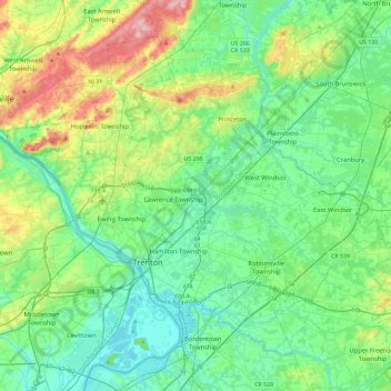
Name: Mercer County topographic map, elevation, terrain.
Location: Mercer County, New Jersey, United States of America (40.13684 -74.94291 40.42424 -74.48120)
Average elevation: 43 m
Minimum elevation: 0 m
Maximum elevation: 176 m
Other topographic maps
Click on a map to view its topography, its elevation and its terrain.
Ridgewood
United States of America > New Jersey > Ridgewood
Ridgewood, Bergen County, New Jersey, United States of America
Average elevation: 51 m
Ho-Ho-Kus
United States of America > New Jersey > Ho-Ho-Kus
Ho-Ho-Kus, Bergen County, New Jersey, United States of America
Average elevation: 58 m
Ocean County
United States of America > New Jersey
Ocean County, New Jersey, United States of America
Average elevation: 15 m
Passaic County
United States of America > New Jersey
Passaic County, New Jersey, United States of America
Average elevation: 182 m
Trenton
United States of America > New Jersey > Trenton
Trenton, Mercer County, New Jersey, United States of America
Average elevation: 19 m
Hudson County
United States of America > New Jersey
Hudson County, New Jersey, United States of America
Average elevation: 12 m