
Lincoln County topographic map
Interactive map
Click on the map to display elevation.
About this map
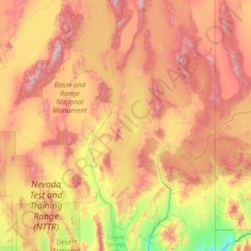
Name: Lincoln County topographic map, elevation, terrain.
Location: Lincoln County, Nevada, United States of America (36.84208 -115.89755 38.67849 -114.04847)
Average elevation: 1,639 m
Minimum elevation: 571 m
Maximum elevation: 3,391 m
According to the U.S. Census Bureau, the county has a total area of 10,637 square miles (27,550 km2), of which 10,633 square miles (27,540 km2) is land and 3.8 square miles (9.8 km2) (0.04%) is water. While only the third largest county by area in the state of Nevada, it is the seventh-largest county in area in the United States, not including boroughs and census areas in Alaska. The south cliff of Mount Rummel, the summit of which is just north of the county line in by this places side: White Pine County, contains the highest point in Lincoln County at 10,640 feet (3,240 m). The highest independent mountain completely within Lincoln County is Shingle Peak, while the county's most topographically prominent peak is Mormon Peak.
Other topographic maps
Click on a map to view its topography, its elevation and its terrain.
Pershing County
United States of America > Nevada
Pershing County, Nevada, United States of America
Average elevation: 1,449 m
Lander County
United States of America > Nevada
Lander County, Nevada, United States of America
Average elevation: 1,768 m
Mesquite
United States of America > Nevada > Mesquite
Mesquite, Clark County, Nevada, United States of America
Average elevation: 601 m
Whitney
United States of America > Nevada > Whitney
Whitney, Clark County, Nevada, United States of America
Average elevation: 524 m
Clark County
United States of America > Nevada
Clark County, Nevada, United States of America
Average elevation: 968 m
North Valley
United States of America > Nevada > Reno > North Valley
North Valley, Reno, Washoe County, Nevada, 89512, United States of America
Average elevation: 1,419 m
Jackman
United States of America > Nevada > Jackman
Jackman, Clark County, Nevada, United States of America
Average elevation: 506 m
Elko County
United States of America > Nevada
Elko County, Nevada, United States of America
Average elevation: 1,838 m