
Daet topographic map
Interactive map
Click on the map to display elevation.
Daet
Daet is located in the southeastern part of Camarines Norte. It is bounded in the east by the town of Mercedes; in the south by the municipality of Basud; in southwest by San Lorenzo Ruiz town; in the north by Pacific Ocean; in the west by San Vicente and northwest by Talisay. The provincial capital covers a total land area of 5,861.48 hectares. The landscape of Daet is primarily composed of plains or flatlands, with no significant mountains or valleys. The average elevation of the area is approximately 10 meters above sea level.
About this map
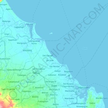
Name: Daet topographic map, elevation, terrain.
Location: Daet, Camarines Norte, Bicol Region, 4600, Philippines (14.07362 122.89669 14.26107 123.07859)
Average elevation: 6 m
Minimum elevation: -1 m
Maximum elevation: 114 m
Other topographic maps
Click on a map to view its topography, its elevation and its terrain.