
Richmond Hill topographic map
Interactive map
Click on the map to display elevation.
About this map
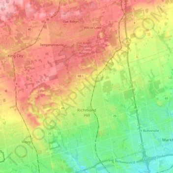
Name: Richmond Hill topographic map, elevation, terrain.
Average elevation: 256 m
Minimum elevation: 171 m
Maximum elevation: 350 m
The village of Richmond Hill was incorporated by a bylaw of the York County Council on June 18, 1872, coming into effect January 1, 1873. In September 1956, the Ontario Municipal Board approved its elevation to Town status, effective January 1, 1957.
Other topographic maps
Click on a map to view its topography, its elevation and its terrain.
King
Canada > Ontario > York Region
King, East Gwillimbury, York Region, Golden Horseshoe, Ontario, Canada
Average elevation: 266 m