
Brownsville topographic map
Interactive map
Click on the map to display elevation.
About this map
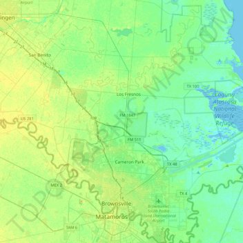
Name: Brownsville topographic map, elevation, terrain.
Location: Brownsville, Cameron County, Texas, United States (25.84019 -97.64455 26.21751 -97.27364)
Average elevation: 9 m
Minimum elevation: -3 m
Maximum elevation: 25 m
Soils are mostly of clay to silty clay loam texture, moderately alkaline (pH 8.2) to strongly alkaline (pH 8.5 and with a significant degree of salinity in many places; other types of soils present around the city include Cameron clay and sporadic amounts of Laredo silt loam. Due to Brownsville's proximity to the coast, Lomalta clay is common around the swamp areas of the vicinity. Several parts of the city have a high risk of localized flooding because of flat topography, ubiquitous low-permeability clay soils, and inadequate infrastructure funding.