
Elbląg topographic map
Interactive map
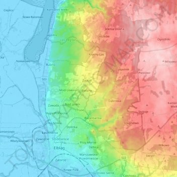
Click on the map to display elevation.
About this map
Name: Elbląg topographic map, elevation, terrain.
Average elevation: 75 m
Minimum elevation: -6 m
Maximum elevation: 197 m
The modern city adjoins about half the length of the river between Lake Drużno and Elbląg Bay (Zatoka Elbląska, an arm of the Vistula Lagoon), and spreads out on both banks, though mainly on the eastern side. To the east is the Elbląg Upland (Wysoczyzna Elbląska), a dome pushed up by glacial compression, 390 km2 in diameter and 200 m (656.17 ft) high at its greatest elevation. It gives the appearance of ridges and parkland.
Other topographic maps
Click on a map to view its topography, its elevation and its terrain.
Dost
Poland > Warmian-Masurian Voivodeship > Olsztyn County > Polkajmy
Dost, Polkajmy, gmina Jeziorany, Olsztyn County, Warmian-Masurian Voivodeship, 11-320, Poland
Average elevation: 119 m
Olsztyn
Poland > Warmian-Masurian Voivodeship > Olsztyn
Olsztyn, Warmian-Masurian Voivodeship, Poland
Average elevation: 123 m
Pisz
Poland > Warmian-Masurian Voivodeship > Pisz County > Pisz > Pisz
Pisz, gmina Pisz, Pisz County, Warmian-Masurian Voivodeship, 12-200, Poland
Average elevation: 118 m
Mrągowo County
Poland > Warmian-Masurian Voivodeship
Mrągowo County, Warmian-Masurian Voivodeship, Poland
Average elevation: 141 m
Olsztyn
Poland > Warmian-Masurian Voivodeship
Olsztyn, Olsztyn County, Warmian-Masurian Voivodeship, Poland
Average elevation: 123 m
Mrągowo
Poland > Warmian-Masurian Voivodeship > Mrągowo
Mrągowo, powiat mrągowski, Warmian-Masurian Voivodeship, 11-700, Poland
Average elevation: 150 m
Olsztynek
Poland > Warmian-Masurian Voivodeship > Olsztynek
Olsztynek, gmina Olsztynek, powiat olsztyński, Warmian-Masurian Voivodeship, 11-015, Poland
Average elevation: 174 m
Olecko
Poland > Warmian-Masurian Voivodeship > Olecko
Olecko, gmina Olecko, powiat olecki, Warmian-Masurian Voivodeship, 19-401, Poland
Average elevation: 170 m