
Ongaonga topographic map
Interactive map
Click on the map to display elevation.
About this map
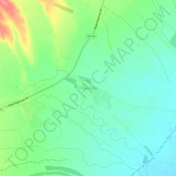
Name: Ongaonga topographic map, elevation, terrain.
Average elevation: 206 m
Minimum elevation: 181 m
Maximum elevation: 261 m
Other topographic maps
Click on a map to view its topography, its elevation and its terrain.
Waipawa Hill
New Zealand > Hawke's Bay > Central Hawke's Bay District
Waipawa Hill, Central Hawke's Bay District, Hawke's Bay, 4210, New Zealand
Average elevation: 253 m
Waipukurau
New Zealand > Hawke's Bay > Central Hawke's Bay District
Waipukurau, Central Hawke's Bay District, Hawke's Bay, 4200, New Zealand
Average elevation: 153 m
Kairakau Beach
New Zealand > Hawke's Bay > Central Hawke's Bay District
Kairakau Beach, Central Hawke's Bay District, Hawke's Bay, New Zealand
Average elevation: 46 m
Otane
New Zealand > Hawke's Bay > Central Hawke's Bay District
Otane, Central Hawke's Bay District, Hawke's Bay, 4202, New Zealand
Average elevation: 120 m