
Hopfgarten im Brixental topographic map
Interactive map
Click on the map to display elevation.
About this map
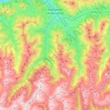
Name: Hopfgarten im Brixental topographic map, elevation, terrain.
Location: Hopfgarten im Brixental, Kitzbühel, Tyrol, 6361, Austria (47.26884 12.00411 47.47105 12.20467)
Average elevation: 1,438 m
Minimum elevation: 511 m
Maximum elevation: 2,435 m