
Bath topographic map
Interactive map
Click on the map to display elevation.
About this map
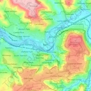
Name: Bath topographic map, elevation, terrain.
Average elevation: 100 m
Minimum elevation: 14 m
Maximum elevation: 235 m
The floodplain of the Avon has an altitude of about 59 ft (18 m) above sea level, although the city centre is at an elevation of around 25 metres (82 ft) above sea level. The river, once an unnavigable series of braided streams broken up by swamps and ponds, has been managed by weirs into a single channel. Periodic flooding, which shortened the life of many buildings in the lowest part of the city, was normal until major flood control works were completed in the 1970s. Kensington Meadows is an area of mixed woodland and open meadow next to the river which has been designated as a local nature reserve.
Other topographic maps
Click on a map to view its topography, its elevation and its terrain.
Bathford
United Kingdom > England > Bath and North East Somerset
Bathford, Bath and North East Somerset, West of England, England, United Kingdom
Average elevation: 104 m