
Kandy topographic map
Interactive map
Click on the map to display elevation.
About this map
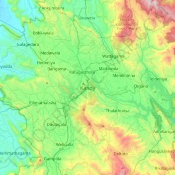
Name: Kandy topographic map, elevation, terrain.
Location: Kandy, Kandy District, Central Province, 20000, Sri Lanka (7.13309 80.47508 7.45309 80.79508)
Average elevation: 621 m
Minimum elevation: 145 m
Maximum elevation: 1,837 m
Other topographic maps
Click on a map to view its topography, its elevation and its terrain.
Lewella Junction
Sri Lanka > Central Province > Kandy > Lewella Junction
Lewella Junction, Kandy, Kandy District, Central Province, 2000, Sri Lanka
Average elevation: 531 m