
Morelia topographic map
Interactive map
Click on the map to display elevation.
About this map
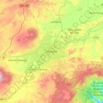
Name: Morelia topographic map, elevation, terrain.
Location: Morelia, Michoacán, 58000, Mexico (19.54271 -101.35238 19.86271 -101.03238)
Average elevation: 2,071 m
Minimum elevation: 1,323 m
Maximum elevation: 2,989 m
Under the Köppen climate classification, Morelia has a subtropical highland climate (Cwb), with warm-to-hot days and cool nights year round due to its high elevation. Most precipitation falls during the summer rainy season. Average monthly temperatures are between 14 and 22 °C (57 and 72 °F), with maximum temperatures of 38.3 °C (100.9 °F) in the summer of 1998 and the lowest temperature of −5.2 °C (22.6 °F) in January 1985.