
Mashonaland Central Province topographic map
Interactive map
Click on the map to display elevation.
About this map
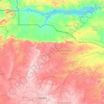
Name: Mashonaland Central Province topographic map, elevation, terrain.
Location: Mashonaland Central Province, Zimbabwe (-17.74197 30.04074 -15.62092 32.76116)
Average elevation: 859 m
Minimum elevation: 314 m
Maximum elevation: 1,724 m
Other topographic maps
Click on a map to view its topography, its elevation and its terrain.
Runanga
Zimbabwe > Mashonaland East Province > Goromonzi
Runanga, Goromonzi, Mashonaland East Province, Zimbabwe
Average elevation: 1,500 m
Bulawayo
Zimbabwe > Bulawayo Province > Bulawayo
Bulawayo, Bulawayo Province, Zimbabwe
Average elevation: 1,348 m
Mount Nyangani
Mount Nyangani, Nyanga, Manicaland, Zimbabwe
Average elevation: 2,329 m
Lake Chivero
Lake Chivero, Kamba Caravan Park Acces Road, Zvimba, Mashonaland West, Zimbabwe
Average elevation: 1,382 m