
Bafra topographic map
Interactive map
Click on the map to display elevation.
About this map
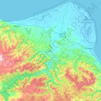
Name: Bafra topographic map, elevation, terrain.
Location: Bafra, Samsun, Black Sea Region, Turkey (41.22633 35.49610 41.73794 36.11171)
Average elevation: 338 m
Minimum elevation: -4 m
Maximum elevation: 1,602 m
Other topographic maps
Click on a map to view its topography, its elevation and its terrain.
Camili
Turkey > Black Sea Region > Camili
Camili, Giresun District, Giresun, Black Sea Region, 28100, Turkey
Average elevation: 304 m