
New York County topographic map
Interactive map
Click on the map to display elevation.
About this map
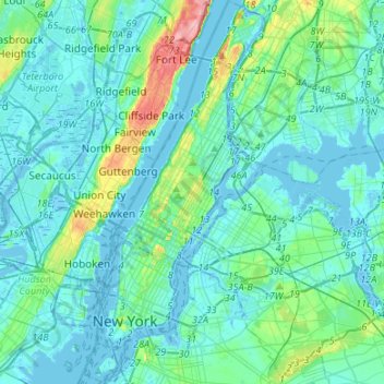
Name: New York County topographic map, elevation, terrain.
Location: New York County, New York, United States (40.67965 -74.04721 40.88201 -73.90677)
Average elevation: 16 m
Minimum elevation: -9 m
Maximum elevation: 117 m
Other topographic maps
Click on a map to view its topography, its elevation and its terrain.
Grasmere Lake
United States > New York > New York
Grasmere Lake, Staten Island, New York, United States
Average elevation: 27 m
Queens County
United States > New York > New York
Queens County, New York, United States
Average elevation: 11 m