
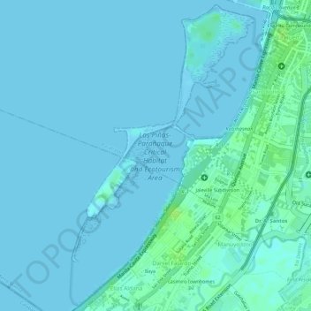
Las Piñas-Parañaque Critical Habitat and Ecotourism Area topographic map
Interactive map
Click on the map to display elevation.
About this map
Name: Las Piñas-Parañaque Critical Habitat and Ecotourism Area topographic map, elevation, terrain.
Average elevation: 3 m
Minimum elevation: -1 m
Maximum elevation: 12 m
Freedom Island covers an area of about 74 acres (0.30 km2) with an elevation of between 0 and 7 meters above sea level. It is a barrier island located across from the Manila–Cavite Expressway just south of another reclaimed site called Asiaworld City, a residential waterfront community that is part of the bigger Bay City development. The island runs along the coast from barangay La Huerta at its north end near the mouth of Parañaque River into barangay San Dionisio right at the border with Las Piñas. A narrow landfill connects its southern tip to the mainland and Long Island near the expressway toll barrier.
Other topographic maps
Click on a map to view its topography, its elevation and its terrain.
Pilar
Pilar, 2nd District, Las Piñas, Southern Manila District, Metro Manila, 1750, Philippines
Average elevation: 36 m
Zapote
Zapote, 1st District, Las Piñas, Southern Manila District, Metro Manila, Philippines
Average elevation: 6 m
Talon Dos
Talon Dos, 2nd District, Las Piñas, Metro Manila, Philippines
Average elevation: 19 m
Las Piñas
Las Piñas, 1st District, Fourth District, Metro Manila, Philippines
Average elevation: 26 m
Las Piñas River
Las Piñas River, Pulanglupa Dos, Las Piñas, 1st District, Fourth District, Metro Manila, 1742, Philippines
Average elevation: 13 m
Ilaya
Ilaya, Las Piñas, 1st District, Fourth District, Metro Manila, Philippines
Average elevation: 5 m