
Summit Peak topographic map
Interactive map
Click on the map to display elevation.
About this map
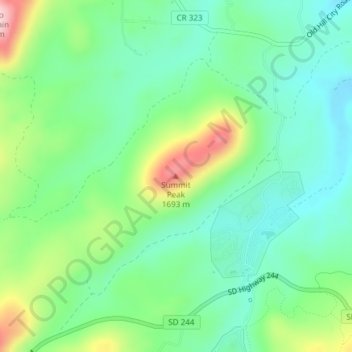
Name: Summit Peak topographic map, elevation, terrain.
Location: Summit Peak, Pennington County, South Dakota, 57745, USA (43.90883 -103.54385 43.90893 -103.54375)
Average elevation: 1,566 m
Minimum elevation: 1,497 m
Maximum elevation: 1,719 m
Other topographic maps
Click on a map to view its topography, its elevation and its terrain.
Beresford
USA > South Dakota > Beresford
Beresford, Union County, South Dakota, USA
Average elevation: 456 m
Missouri River
Missouri River, Sully County, South Dakota, 64072, USA
Average elevation: 901 m
Mount McKinley
Mount McKinley, Harding County, South Dakota, USA
Average elevation: 980 m