
Attica topographic map
Interactive map
Click on the map to display elevation.
About this map
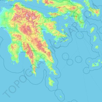
Name: Attica topographic map, elevation, terrain.
Location: Attica, Greece (35.72143 22.76581 38.37816 24.14635)
Average elevation: 155 m
Minimum elevation: -5 m
Maximum elevation: 2,327 m
Other topographic maps
Click on a map to view its topography, its elevation and its terrain.
Chalandri
Greece > Attica > Regional Unit of North Athens
Chalandri, Municipality of Chalandri, Regional Unit of North Athens, Attica, 152 32, Greece
Average elevation: 222 m
Piraeus
Greece > Attica > Regional Unit of Piraeus
Piraeus, Municipality of Piraeus, Regional Unit of Piraeus, Attica, 185 35, Greece
Average elevation: 96 m
Olympus
Greece > Attica > Regional Unit of North Athens > Municipal Unit of Psychiko
Olympus, Municipal Unit of Psychiko, Municipality of Filothei - Psychiko, Regional Unit of North Athens, Attica, 154 52, Greece
Average elevation: 204 m
Vouliagmeni Municipal Unit
Greece > Attica > Regional Unit of East Attica
Vouliagmeni Municipal Unit, Municipality of Vari - Voula - Vouliagmeni, Regional Unit of East Attica, Attica, 166 71, Greece
Average elevation: 20 m
Athens
Greece > Attica > Regional Unit of Central Athens
Athens, Municipality of Athens, Regional Unit of Central Athens, Attica, 104 31, Greece
Average elevation: 178 m
Municipality of Acharnes
Municipality of Acharnes, Regional Unit of East Attica, Region of Attica, Attica, Greece
Average elevation: 490 m