
Cheshire County topographic map
Interactive map
Click on the map to display elevation.
About this map
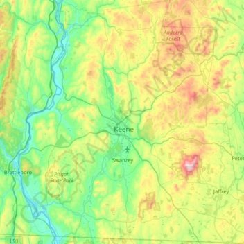
Name: Cheshire County topographic map, elevation, terrain.
Location: Cheshire County, New Hampshire, United States (42.71216 -72.55724 43.18196 -71.92886)
Average elevation: 308 m
Minimum elevation: 54 m
Maximum elevation: 944 m
Other topographic maps
Click on a map to view its topography, its elevation and its terrain.
Dover
United States > New Hampshire > Strafford County
Dover, Strafford County, New Hampshire, 03820, United States
Average elevation: 31 m
Jaffrey
United States > New Hampshire > Cheshire County
Jaffrey, Cheshire County, New Hampshire, 03452, United States
Average elevation: 351 m
Atkinson
United States > New Hampshire > Rockingham County
Atkinson, Rockingham County, New Hampshire, 03811, United States
Average elevation: 63 m
Laconia
United States > New Hampshire > Belknap County
Laconia, Belknap County, New Hampshire, United States
Average elevation: 203 m
Tuftonboro
United States > New Hampshire > Tuftonboro
Tuftonboro, Carroll County, New Hampshire, United States
Average elevation: 256 m
Hudson
United States > New Hampshire > Hudson
Hudson, Hillsborough County, New Hampshire, 03051, United States
Average elevation: 68 m
Exeter
United States > New Hampshire > Exeter
Exeter, Rockingham County, New Hampshire, United States
Average elevation: 24 m
Durham
United States > New Hampshire > Durham
Durham, Strafford County, New Hampshire, 03824, United States
Average elevation: 23 m
Manchester
United States > New Hampshire > Hillsborough County
Manchester, Hillsborough County, New Hampshire, United States
Average elevation: 96 m
Grafton County
Grafton County, New Hampshire, United States
Average elevation: 424 m