
Mount Wellington topographic map
Interactive map
Click on the map to display elevation.
About this map
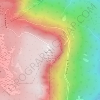
Name: Mount Wellington topographic map, elevation, terrain.
Location: Mount Wellington, City of Hobart, Tasmania, Australia (-42.89606 147.23726 -42.89596 147.23736)
Average elevation: 941 m
Minimum elevation: 443 m
Maximum elevation: 1,263 m
"... In many parts the Eucalypti grew to a great size, and composed a noble forest. In some of the dampest ravines, tree-ferns flourished in an extraordinary manner; I saw one which must have been at least twenty feet high to the base of the fronds, and was in girth exactly six feet. The fronds forming the most elegant parasols, produced a gloomy shade, like that of the first hour of the night. The summit of the mountain is broad and flat, and is composed of huge angular masses of naked greenstone. Its elevation is 3,100 feet above the level of the sea. The day was splendidly clear, and we enjoyed a most extensive view; to the north, the country appeared a mass of wooded mountains, of about the same height with that on which we were standing, and with an equally tame outline: to the south the broken land and water, forming many intricate bays, was mapped with clearness before us. ..."
Other topographic maps
Click on a map to view its topography, its elevation and its terrain.
Mount Lloyd
Mount Lloyd, Derwent Valley, Tasmania, 7140, Australia
Average elevation: 558 m
Curtis Island
Curtis Island, Flinders Council, Tasmania, Australia
Average elevation: 18 m
Cataract Gorge Reserve
Australia > Tasmania > Launceston
Cataract Gorge Reserve, Launceston, City of Launceston, Tasmania, 7250, Australia
Average elevation: 125 m
Dove Lake
Australia > Tasmania > Cradle Mountain
Dove Lake, Cradle Mountain, Kentish, Tasmania, Australia
Average elevation: 1,060 m
Queenstown
Queenstown, West Coast, Tasmania, 7467, Australia
Average elevation: 330 m
Legana
Australia > Tasmania > Launceston > Legana
Legana, Launceston, West Tamar, Tasmania, Australia
Average elevation: 82 m
Launceston
Launceston, City of Launceston, Tasmania, 7250, Australia
Average elevation: 26 m
King Island Council
King Island Council, Tasmania, Australia
Average elevation: 14 m
Binalong Bay
Australia > Tasmania > Binalong Bay
Binalong Bay, Tasmania, Australia
Average elevation: 23 m
Lake McRae
Lake McRae, Overland Track, Tasmania, Australia
Average elevation: 1,044 m
Lake Dobson
Lake Dobson, Pandani Grove Nature Walk, Tasmania, Australia
Average elevation: 1,093 m
Lake Margaret
Australia > Tasmania > Lake Margaret
Lake Margaret, Tasmania, Australia
Average elevation: 436 m
Blythe River
Blythe River, Burnie, Tasmania, 7320, Australia
Average elevation: 99 m