
Noble Island topographic map
Interactive map
Click on the map to display elevation.
About this map
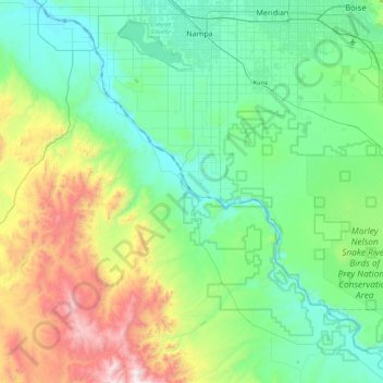
Name: Noble Island topographic map, elevation, terrain.
Location: Noble Island, Owyhee County, Idaho, USA (42.98906 -116.89816 43.62906 -116.25816)
Average elevation: 1,053 m
Minimum elevation: 671 m
Maximum elevation: 2,435 m
Other topographic maps
Click on a map to view its topography, its elevation and its terrain.
American Falls
USA > Idaho > American Falls
American Falls, Power County, Idaho, 83211, USA
Average elevation: 1,345 m
Memory Ranch Rock
Memory Ranch Rock, West Memorial Way, Kuna, Ada County, Idaho, USA
Average elevation: 810 m