
Riga topographic map
Interactive map
Click on the map to display elevation.
About this map
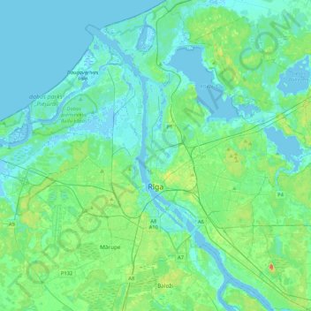
Name: Riga topographic map, elevation, terrain.
Location: Riga, Vidzeme, Latvia (56.85735 23.93237 57.08598 24.32484)
Average elevation: 7 m
Minimum elevation: -5 m
Maximum elevation: 39 m
Other topographic maps
Click on a map to view its topography, its elevation and its terrain.
Brantu pagasts
Latvia > Vidzeme > Smiltenes novads
Brantu pagasts, Smiltenes novads, Vidzeme, Latvia
Average elevation: 169 m
Brantu dzirnavezers
Latvia > Vidzeme > Raunas pagasts
Brantu dzirnavezers, Smiltenes iela, Bormaņi 1, Raunas pagasts, Raunas novads, Vidzeme, LV-4131, Latvia
Average elevation: 191 m
Lake Burtnieks
Lake Burtnieks, Ezera iela, Kalmes, Burtnieki, Burtnieku novads, Vidzeme, Latvia
Average elevation: 45 m