
Rewa topographic map
Interactive map
Click on the map to display elevation.
About this map
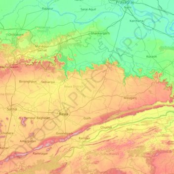
Name: Rewa topographic map, elevation, terrain.
Location: Rewa, Madhya Pradesh, India (24.11000 80.86000 25.39000 82.14000)
Average elevation: 259 m
Minimum elevation: 65 m
Maximum elevation: 701 m
Other topographic maps
Click on a map to view its topography, its elevation and its terrain.
Patharia
India > Madhya Pradesh > Patharia Tahsil > Patharia
Patharia, Patharia Tahsil, Damoh District, Madhya Pradesh, India
Average elevation: 376 m
Huzur Tahsil
Huzur Tahsil, Bhopal District, Madhya Pradesh, India
Average elevation: 494 m
Bagya
India > Madhya Pradesh > Mandsaur Tahsil
Bagya, Mandsaur Tahsil, Mandsaur, Madhya Pradesh, India
Average elevation: 452 m
Tapti River
Tapti River, West Nimār, Khargone, Madhya Pradesh, 394180, India
Average elevation: 374 m
Narmada
Narmada, Hoshangābād, Hoshangabad, Madhya Pradesh, 481880, India
Average elevation: 380 m