
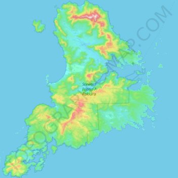
Stewart Island / Rakiura Community topographic map
Interactive map
Click on the map to display elevation.
About this map
Name: Stewart Island / Rakiura Community topographic map, elevation, terrain.
Average elevation: 63 m
Minimum elevation: -2 m
Maximum elevation: 967 m
Southland District trails, hiking, mountain biking, running and outdoor activities
Other topographic maps
Click on a map to view its topography, its elevation and its terrain.
Makarewa Junction
New Zealand > Southland > Southland District > Oreti Community
Average elevation: 17 m
Waimānu / Stirling Falls
New Zealand > Southland > Southland District > Fiordland Community
Average elevation: 423 m
Hineteawa / Bowen Falls
New Zealand > Southland > Southland District > Fiordland Community
Average elevation: 232 m
Edendale
New Zealand > Southland > Southland District > Waihopai Toetoe Community
Average elevation: 41 m
Clifden
New Zealand > Southland > Southland District > Tuatapere Te Waewae Community
Average elevation: 70 m
Oban
New Zealand > Southland > Southland District > Stewart Island / Rakiura Community
Average elevation: 23 m
Eldrig Peak
New Zealand > Southland > Southland District > Fiordland Community
Average elevation: 1,155 m
Nightcaps
New Zealand > Southland > Southland District > Wallace Takitimu Community
Average elevation: 183 m
Roslyn Bush
New Zealand > Southland > Southland District > Waihopai Toetoe Community
Average elevation: 29 m
Mount Elliot
New Zealand > Southland > Southland District > Fiordland Community
Average elevation: 1,110 m
Oban
New Zealand > Southland > Southland District > Stewart Island / Rakiura Community
Average elevation: 23 m
Lake Innes
New Zealand > Southland > Southland District > Tuatapere Te Waewae Community
Average elevation: 223 m
Riverton
New Zealand > Southland > Southland District > Oraka Aparima Community
Average elevation: 16 m
Pearl Harbour
New Zealand > Southland > Southland District > Fiordland Community > Manapouri
Average elevation: 212 m
Merrivale
New Zealand > Southland > Southland District > Tuatapere Te Waewae Community
Average elevation: 192 m
Sutherland Falls
New Zealand > Southland > Southland District > Fiordland Community
Average elevation: 1,006 m
Mount Owen
New Zealand > Southland > Southland District > Fiordland Community
Average elevation: 1,269 m
The Downs
New Zealand > Southland > Southland District > Tuatapere Te Waewae Community
Average elevation: 34 m
Turner Falls
New Zealand > Southland > Southland District > Fiordland Community
Average elevation: 1,335 m
Mount Makere
New Zealand > Southland > Southland District > Fiordland Community
Average elevation: 1,433 m
White Peak
New Zealand > Southland > Southland District > Tuatapere Te Waewae Community
Average elevation: 1,153 m
Waikawa
New Zealand > Southland > Southland District > Waihopai Toetoe Community > Waikawa
Average elevation: 39 m
Depth Peak
New Zealand > Southland > Southland District > Fiordland Community
Average elevation: 680 m
Milford Sound
New Zealand > Southland > Southland District > Fiordland Community > Milford Sound
Average elevation: 304 m
Mitre Peak
New Zealand > Southland > Southland District > Fiordland Community
Average elevation: 657 m
Blackmount
New Zealand > Southland > Southland District > Tuatapere Te Waewae Community > Blackmount
Average elevation: 170 m