Geolocate

Tasman District topographic map

Interactive map

Click on the map to display elevation.

About this map

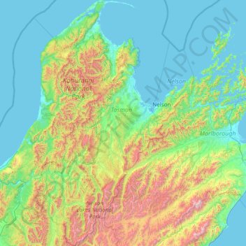
Name: Tasman District topographic map, elevation, terrain.

Location: Tasman District, Tasman, New Zealand (-42.30557 172.05059 -40.49786 173.30442)

Average elevation: 463 m

Minimum elevation: -1 m

Maximum elevation: 2,764 m

Tasman trails, hiking, mountain biking, running and outdoor activities

Other topographic maps

Click on a map to view its topography, its elevation and its terrain.

Onekaka

New Zealand > Tasman

Average elevation: 73 m

Saddle Creek

New Zealand > Tasman > Tasman District

Average elevation: 853 m

Adele

New Zealand > Tasman

Average elevation: 11 m

Motueka

New Zealand > Tasman

Average elevation: 12 m

Mount Snowdon

New Zealand > Tasman

Average elevation: 1,410 m

Tableland

New Zealand > Tasman > Tasman District

Average elevation: 779 m

Mount Hopeless

New Zealand > Tasman

Average elevation: 1,743 m

Richmond

New Zealand > Tasman

Average elevation: 83 m

Ruby Bay

New Zealand > Tasman > Ruby Bay

Average elevation: 23 m

Wakefield

New Zealand > Tasman > Wakefield

Average elevation: 134 m

Brightwater

New Zealand > Tasman > Brightwater

Average elevation: 73 m

Franklin Ridge

New Zealand > Tasman

Average elevation: 1,474 m

Upper Takaka

New Zealand > Tasman > Upper Takaka

Average elevation: 202 m

Warwick Junction

New Zealand > Tasman

Average elevation: 429 m

Mt. Douglas

New Zealand > Tasman

Average elevation: 1,203 m