
Sevenoaks topographic map
Interactive map
Click on the map to display elevation.
About this map
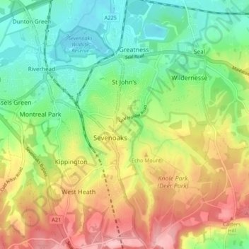
Name: Sevenoaks topographic map, elevation, terrain.
Location: Sevenoaks, Kent, England, United Kingdom (51.24917 0.17035 51.30013 0.22526)
Average elevation: 127 m
Minimum elevation: 62 m
Maximum elevation: 218 m
Other topographic maps
Click on a map to view its topography, its elevation and its terrain.
New Ash Green
United Kingdom > England > Kent > Sevenoaks
New Ash Green, Sevenoaks, Kent, England, DA3 8JF, United Kingdom
Average elevation: 123 m
The Masthead
United Kingdom > England > Kent > Sevenoaks
The Masthead, Sevenoaks, Kent, England, TN15 0RT, United Kingdom
Average elevation: 149 m