
Tihiroa topographic map
Interactive map
Click on the map to display elevation.
About this map
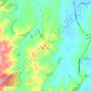
Name: Tihiroa topographic map, elevation, terrain.
Location: Tihiroa, Otorohanga District, Waikato, New Zealand (-38.12038 175.18166 -38.12028 175.18176)
Average elevation: 88 m
Minimum elevation: 32 m
Maximum elevation: 206 m
Other topographic maps
Click on a map to view its topography, its elevation and its terrain.
Kawhia
New Zealand > Waikato > Otorohanga District
Kawhia, Otorohanga District, Waikato, 3843, New Zealand
Average elevation: 26 m
Ōparau River
New Zealand > Waikato > Otorohanga District
Ōparau River, Otorohanga District, Waikato, New Zealand
Average elevation: 138 m
Waikeria
New Zealand > Waikato > Otorohanga District
Waikeria, Otorohanga District, Waikato, 3873, New Zealand
Average elevation: 66 m