
Wrightwood topographic map
Interactive map
Click on the map to display elevation.
About this map
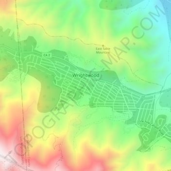
Name: Wrightwood topographic map, elevation, terrain.
Average elevation: 1,952 m
Minimum elevation: 1,552 m
Maximum elevation: 2,536 m
Wrightwood is a census-designated place in San Bernardino County, California. It sits at an elevation of 6,000 feet (1,800 m). The population was 4,525 at the 2010 census, up from the population of 3,837 at the 2000 census. Wrightwood is located 77 miles (124 km) northeast of Los Angeles. Wrightwood is on the Pacific Crest Trail.
Other topographic maps
Click on a map to view its topography, its elevation and its terrain.
Chino
United States > California > San Bernardino County
Chino, San Bernardino County, California, United States
Average elevation: 239 m
Rancho Cucamonga
United States > California > San Bernardino County
Rancho Cucamonga, San Bernardino County, California, United States
Average elevation: 539 m
Chino Hills
United States > California > San Bernardino County
Chino Hills, San Bernardino County, California, United States
Average elevation: 255 m