
Daly City topographic map
Interactive map
Click on the map to display elevation.
About this map
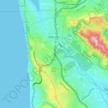
Name: Daly City topographic map, elevation, terrain.
Location: Daly City, San Mateo County, California, United States (37.64852 -122.50082 37.70827 -122.40514)
Average elevation: 75 m
Minimum elevation: 0 m
Maximum elevation: 376 m
Several golf courses are located within or straddle the border with San Francisco. The Olympic Club has hosted the USGA U.S. Open five times, most recently in 2012, and will host both the 2028 PGA Championship and the 2032 Ryder Cup. The private San Francisco Golf Club and Lake Merced Golf Club have part or all of their course in Daly City. The Golden Gate National Recreation Area includes the city's Thornton Beach. The topography of this area (due to the San Andreas fault) is conducive to paragliding and hang gliding.
Other topographic maps
Click on a map to view its topography, its elevation and its terrain.
Pacifica
United States > California > San Mateo County
Pacifica, San Mateo County, California, 94044, United States
Average elevation: 76 m
City Hall Park
United States > California > San Mateo County > San Carlos
City Hall Park, San Carlos, San Mateo County, CAL Fire Northern Region, California, United States
Average elevation: 33 m