
Bridlington topographic map
Interactive map
Click on the map to display elevation.
About this map
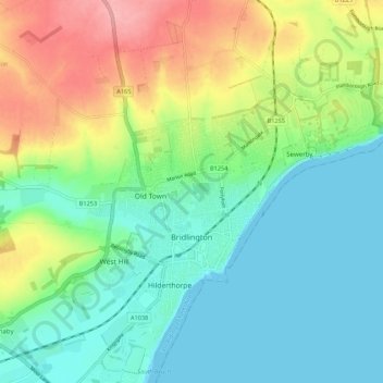
Name: Bridlington topographic map, elevation, terrain.
Location: Bridlington, East Riding of Yorkshire, England, United Kingdom (54.06355 -0.24967 54.12586 -0.14117)
Average elevation: 35 m
Minimum elevation: 0 m
Maximum elevation: 106 m
Other topographic maps
Click on a map to view its topography, its elevation and its terrain.
Foston on the Wolds
United Kingdom > England > East Riding of Yorkshire
Foston on the Wolds, East Riding of Yorkshire, England, YO25 8BN, United Kingdom
Average elevation: 8 m
Aldbrough
United Kingdom > England > East Riding of Yorkshire
Aldbrough, East Riding of Yorkshire, England, HU11 4RP, United Kingdom
Average elevation: 11 m