
Reichelsheim (Odenwald) topographic map
Interactive map
Click on the map to display elevation.
Reichelsheim (Odenwald)
Reichelsheim lies in the middle Odenwald at elevations between 200 and 538 m in the middle of the Geo-Naturpark Bergstraße-Odenwald.
About this map
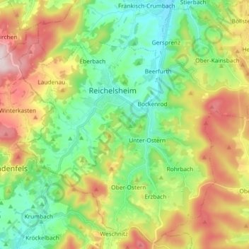
Name: Reichelsheim (Odenwald) topographic map, elevation, terrain.
Location: Reichelsheim (Odenwald), Odenwaldkreis, Hesse, 64385, Germany (49.65582 8.78444 49.74506 8.92912)
Average elevation: 335 m
Minimum elevation: 179 m
Maximum elevation: 595 m